Spie relies on the digital twin for its construction sites
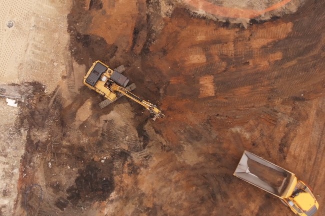
Specialist in earthworks, Spie batignolles valrian deploys 3D models, coupled with GPS tablets, to better understand the terrain and enhance the materials extracted during its construction sites.
Use the digital model and BIM to precisely identify the characteristics of the excavated land in order to facilitate its reuse. It is this principle that Spie batignolles valérian, the entity specialized in earthmoving of the construction, civil engineering and public works group, has implemented. The project was tested on the site of the Seine Nord Canal, which is to link the Seine and the Scheldt and which is scheduled to open in 2030. Developed by the company, the solution contributed to its selection as part of the tender on this site.
The objective of this development? Valorize a maximum of earth directly on the extraction site, limiting deposits in temporary stocks. To do this, the Spie batignolles teams have created a 3D model of the terrain allowing the drivers of the excavators, themselves equipped with a GPS guidance system, to know the nature and thickness of the material under their tracks as the progress of the site progresses. This makes it possible to mix the earth directly at the excavation site while ensuring that this mixture complies with the conditions of reuse. “With our method, we were able to halve the number of operating hours of our machines, save space, significantly reduce the carbon impact of the site by limiting the flow of trucks and present an optimized budget to our customer,” details Maurice Bufalo, technical director and quality of realization of Spie batignolles valérian.
Sorting out polluted land
This same technique is also exploited by the group of 7,700 people on the construction site of the Eole Line, where potentially polluted land is excavated. In this second case, the company began by building a digital geochemical model based on samples and analyzes to classify the severity of the pollution suffered by the soils. The volume thus analyzed is broken down into cubes of materials having the same level of pollution, each being associated with a color code. During excavations, guided by a GPS tablet, the excavator driver can therefore know the nature of the material encountered, which allows him to assemble the land with the same level of contamination before their recovery or their routing to suitable landfill sites.
“While generally, as a precautionary principle, companies transport potentially polluted land to landfill sites, this technique allows us to sort the materials to enhance those that are suitable. For example, on a construction site in Greater Paris, we managed to recover 85% of the excavated land thanks to the geological categorization carried out upstream,” adds Maurice Bufalo.
You May Also Like


More From Author

ServReality Brings Next-Gen Gaming Experiences to Apple Devices
January 23, 2026


The Top 25 Diamond and Pearl Pokémon
August 5, 2024